Open Map
Close Map
N
Projections and Nav Modes
  • Normal View
  • Fisheye View
  • Architectural View
  • Stereographic View
  • Little Planet View
  • Panini View
Click and Drag / QTVR mode
Dieses Panorama mit anderen teilen
For Non-Commercial Use Only
This panorama can be embedded into a non-commercial site at no charge. Lesen Sie mehr
Do you agree to the Terms & Conditions?
For commercial use, Kontaktieren Sie uns
Embed this Panorama
BreiteHöhe
For Non-Commercial Use Only
For commercial use, Kontaktieren Sie uns
LICENSE MODAL

0 Likes

Bill's Hill, Henry W Coe State Park, California
California

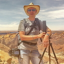
Bill's Hill is a 1988' high peak on the southern boundary of Henry W Coe SP in central California. Monterey Bay is visible to the south as are portions of the historic Juan Bautista de Anza expedition route of 1776.

Copyright: Paul Liebenberg
Art: Spherical
Resolution: 6400x3200
Taken: 05/06/2011
Hochgeladen: 19/06/2011
Angesehen:

...


Tags: nature; henry coe; california state park; de anza
Mehr über California


It looks like you’re creating an order.
If you have any questions before you checkout, just let us know at info@360cities.net and we’ll get right back to you.