Open Map
Close Map
N
Projections and Nav Modes
  • Normal View
  • Fisheye View
  • Architectural View
  • Stereographic View
  • Little Planet View
  • Panini View
Click and Drag / QTVR mode
Deel dit panorama
For Non-Commercial Use Only
This panorama can be embedded into a non-commercial site at no charge. Lees meer
Do you agree to the Terms & Conditions?
For commercial use, neem contact met ons op
Embed this Panorama
BreedteHoogte
For Non-Commercial Use Only
For commercial use, neem contact met ons op
LICENSE MODAL

1 Like

Lang Combe, Exmoor
England

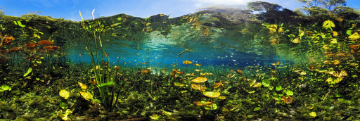
Lang Combe Head on the northweast slope of Dunkery Hill is the source of the Horner Water, which flows for approximately 9km northward to Porlock Bay where it enters the sea. This image is part of a sequence of four, taken as part of a classroom project.

Copyright: Noel Jenkins
Type: Spherical
Resolution: 8144x4072
Taken: 20/06/2009
Geüpload: 21/06/2009
Keer bekeken:

...


Tags: lang combe; exmoor; horner water; geography; river; juicy geography; education
More About England


It looks like you’re creating an order.
If you have any questions before you checkout, just let us know at info@360cities.net and we’ll get right back to you.