0 Likes
از سرزمین طلا
نقشهها و پرترههای رکسانا منوچهری
نقشهها بازنمایی واقعیتی بیرونی هستند که اصولاً در میدان دید انسان قرار نمیگیرد؛ به ویژه وقتی نقشهای از کل جهان، جغرافیای سیاسی یا طبیعی کشورها مورد نظر باشد، واقعیتی ناپیدا در دید در قالب قرارداد تصویر می شود.
علیرغم قراردادی بودن بسیاری از شیوههای نقشهسازی، همیشه جایگاه عامل فردی در این فرآیند برجسته بوده است و کسانی همچون حبش حاسب مروزی در قرن سوم هجری، ابوریحان بیرونی در قرن چهارم و پنجم، و یا پیریرئیس سحاب عثمانی در قرن شانزدهم میلادی با دانش وسیع و خلاقیتهای فردی خود فن نقشهسازی را ارتقاء دادهاند. یعنی نقشههایی تهیه کردهاند که دیگران با دیدن و مشاهده آن، قراردادهای موجود در آن را فهم کرده و آن واقعیت بیرونی که به وسیله نقشه بازنمایی شده است را درک کردهاند. به این عمل خواندن نقشه میگویند و پروژه رکسانا منوچهری نیز متمرکز بر فرآیند خواندن نقشه و چالش با قراردادهای آن است.
در زمانهای که نقشههای استاندارد جغرافیای سیاسی، طبیعی، بومشناسی، جمعیتشناسی و غیره، به دلیل استفاده گسترده و کدهای قراردادی آشنا به سادگی قابل خواندن هستند، رکسانا منوچهری سعی کرده نقشه تازهای در قالب یک پروژه هنری از نظام قدرت جهانی در قرن نوزدهم تهیه کند. او نیز همچون سایر سازندگان نقشهها، کوشش کرده بازنمایی ایده مورد نظر خود را در سه ساحت تصویری، نمادین و نمایهای سازماندهی کند. ساحت نمادین را رنگها نمایندگی میکنند: رنگ طلایی نماد مطلق قدرت است و رنگهای دیگر حوزههای گسترش اقتدار امپراتوریها را نمایندگی میکنند. در ساحت شکلی وتصویری منوچهری از نقشه سیاسی امروزی کشورها استفاده کرده و آن را بر اساس الگوی نمادین رنگ بر نقشه جهان استعماری پایان قرن نوزدهم منطبق کرده است. در واقع او با روی هم انداختن نقشههای سیاسی کشورهای امروز و نقشه جهان استعماری آخر قرن نوزدهم میلادی نوع تازهای از نقشهسازی و همزمان نقشهخوانی را ابداع کرده که درون یک پروژه هنری تعریف میشوند.
از آنجا که اشارههای نمایهای این مجموعه به ایده نقشه ـ به معنای بازنمایی جهان آنگونه که به تصور در میآید ـ اشاره میکند، بنابراین خوانش معانی سرراست آن نیز در امتداد بحث بازنمایی صورت میگیرد. به طور ضمنی، اما، شیوه استفاده منوچهری از شمایلهای سیاسی هر کشور، انتخاب رنگ نمادین برای آن و بعد جاگذاری آن در نقشه هرقاره به نوعی یادآور تکنیک پوآنتیلیستها است. رنگها در هم نمیآمیزند، مرزها به یکدیگر نمیرسند اما کل مجموعه در کنار هم آن بازنمایی ناممکن را تا حدی ممکن میسازد.
علاوه بر ارجاعات سیاسی، تاریخی و جغرافیایی، ارجاعات نمایهای محدود منوچهری به تاریخ هنر و به طور خاص پوآنتیلیسم یادآور این نکته است که این پروژه پیش از هرچیز یک اثر هنری است. یک اثر هنری که مفاهیم و پرسشهای فراموششدهای را در رابطه با بازنمایی به طور ضمنی یادآور میشود.
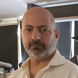
او در بخش دوم این پروژه، مجموعهای از پرترههای سلطنتی را انتخاب و بازآفرینی کرده که به گونهای با نقشه قدرتی که ساخته ارتباط دارند و براساس آن تفسیر میشوند. با این تفاوت که به جای صورت حاکمان و پادشاهان، آینهای گذاشته تا مخاطب چهره خود را اگرنه در جایگاه قدرت، دستکم در لباس قدرت تماشا کند. در بخش پرترهها، دیگر کدهای رنگی حضور ندارند و مخاطب میراث سرزمینی قدرت را میبایست با کمک تخیل خود در برابر آینهای که پیش چشم دارد تصور کند.
رکسانا منوچهری مجموعه «از سرزمین طلا» را بر اساس سه مؤلفه بازنمایی، بازخوانی و تاریخ قدرت سیاسی به تماشا گذاشته است. اینکه نقشههای قراردادی پذیرفته شده تنها امکان برای بازنمایی جهانی که در میدان دید آدمی نمیگنجد نیستند و ادراک و فهم ما از واقعیتی آنچنان عظیم اگرچه بنا به قرارداد در یکی دو قرن گذشته یکدست شده است، اما همچنان امکان تصور و در نتیجه بازنمایی این واقعیت بیرونی بزرگمقیاس به شکلهای دیگر وجود دارد. چیدمان و نمایشگاه رکسانا منوچهری یکی از این امکانات دیگر را معرفی میکند.
سیامک دل زنده
From the Gold Land
Maps and Portraits by Roxana Manouchehri
Maps are the representation of an external reality that is generally hidden from the field of view of humans; especially when they are maps of the world, countries' political or natural geography, a hidden reality projected in the context of a convention.
Despite the conventional ways of producing maps, there have always been people whose efforts have progressed the methodology of map production. People like Habash Haseb Marwazi during the 9th century, Abu Rayhan Al-Biruni during the 10th century and Piri Reis Sahab an Ottoman cartographer during the 16th century have all contributed to the techniques of mapping through their vast knowledge and creativity. They produced maps that could be easily understood and read by others.
This act is known as 'reading maps' and Roxana Manouchehri's project is focused on the process of map reading and in challenging its conventions.
In the era in which provincial maps, geography of politics and nature, ecology, demography, etc can be read easily due to universally understood codes and symbols; Roxana Manouchehri has tried to produce a new kind of map in an artistic context, of global politics of the 19th century. Like other mappers, she has tried to reflect her idea in three spheres: visual, symbolic and indexical. The symbolic sphere is represented by colours: gold is the symbol of ultimate power and other colours represent areas of imperial authority. In the sphere of image, Manouchehri has used countries' contemporary political maps and has adjusted them based on symbolic colours of the colonial world of the late 19th century. In fact, by overlapping the political maps of countries today and the colonial map of the late 19th century, she has invented a new type of mapping and map-reading that is defined within an art project.
Since indexical significations of this project are referencing the idea of maps, as a representation of the world the way it is imagined and depicted, hence denotative meaning of the series is read through meanings of representation. Implicitly, however, Manouchehri's way of using political icons, her choice of iconic colour, and its placement on the map of each continent, in a way, is a reminder of the technique of Pointillists. Colours don't mix and borders don't reach each other, but the collection together makes the impossible, possible.
In addition to political, historical and geographical referrals, Manouchehri's indexical references to art history and to Pointillism in particular shows that this project, more than anything, is Art. It is an art project that connotatively reminds the viewer of forgotten questions and concepts about representation.
In the second part of this project, she has selected and reproduced portraits of royalties that are related to the maps she has used and are interpreted accordingly. The difference is that instead of the faces of rulers and kings, she has placed mirrors so that viewers can see themselves in their place. In the portraits' section, colourful codes no longer exist and the viewer must imagine instead, the heritage of power in front of these mirrors.
Roxana Manouchehri presents From The Gold Land series based on three components: representation, reading and the history of political power. Her choice of contractual maps are not the only way to represent a world outside of our field of vision, and although our understanding of such vast reality has been adjusted according to the realities of two centuries ago, it is still possible to refer to such a large-scale outside reality through them in other ways. Roxana Manouchehri's exhibition introduces one of these possibilities.
...
Overview and HistoryTehran is the capital of Iran and the largest city in the Middle East, with a population of fifteen million people living under the peaks of the Alborz mountain range.Although archaeological evidence places human activity around Tehran back into the years 6000BC, the city was not mentioned in any writings until much later, in the thirteenth century. It's a relatively new city by Iranian standards.But Tehran was a well-known village in the ninth century. It grew rapidly when its neighboring city, Rhages, was destroyed by Mongolian raiders. Many people fled to Tehran.In the seventeenth century Tehran became home to the rulers of the Safavid Dynasty. This is the period when the wall around the city was first constructed. Tehran became the capital of Iran in 1795 and amazingly fast growth followed over the next two hundred years.The recent history of Tehran saw construction of apartment complexes and wide avenues in place of the old Persian gardens, to the detriment of the city's cultural history.The city at present is laid out in two general parts. Northern Tehran is more cosmopolitan and expensive, southern Tehran is cheaper and gets the name "downtown."Getting ThereMehrabad airport is the original one which is currently in the process of being replaced by Imam Khomeini International Airport. The new one is farther away from the city but it now receives all the international traffic, so allow an extra hour to get there or back.TransportationTehran driving can be a wild free-for-all like some South American cities, so get ready for shared taxis, confusing bus routes and a brand new shiny metro system to make it all better. To be fair, there is a great highway system here.The metro has four lines, tickets cost 2000IR, and they have segregated cars. The women-only carriages are the last two at the end, FYI.Taxis come in two flavors, shared and private. Private taxis are more expensive but easier to manage for the visiting traveler. Tehran has a mean rush hour starting at seven AM and lasting until 8PM in its evening version. Solution? Motorcycle taxis! They cut through the traffic and any spare nerves you might have left.People and CultureMore than sixty percent of Tehranis were born outside of the city, making it as ethnically and linguistically diverse as the country itself. Tehran is the most secular and liberal city in Iran and as such it attracts students from all over the country.Things to do, RecommendationsTake the metro to the Tehran Bazaar at the stop "Panzda Gordad". There you can find anything and everything -- shoes, clothes, food, gold, machines and more. Just for the sight of it alone you should take a trip there.If you like being outside, go to Darband and drink tea in a traditional setting. Tehranis love a good picnic and there are plenty of parks to enjoy. Try Mellat park on a friday (fridays are public holidays), or maybe Park Daneshjou, Saaii or Jamshidieh.Remember to go upstairs and have a look around, always always always! The Azadi Tower should fit the bill; it was constructed to commemorate the 2500th anniversary of the Persian Empire.Tehran is also full of museums such as:the Contemporary Art Museumthe Abghine Musuem (glass works)the 19th century Golestan Royal Palace museumthe museum of carpets (!!!)Reza Abbasi Museum of extraordinary miniaturesand most stunning of all,the Crown Jewels Museum which holds the largest pink diamond in the world and many other jaw-dropping jewels.Text by Steve Smith.