Open Map
Close Map
N
Projections and Nav Modes
  • Normal View
  • Fisheye View
  • Architectural View
  • Stereographic View
  • Little Planet View
  • Panini View
Click and Drag / QTVR mode
Condividi questo panorama
For Non-Commercial Use Only
This panorama can be embedded into a non-commercial site at no charge. Leggi oltre
Do you agree to the Terms & Conditions?
For commercial use, Contattaci
Embed this Panorama
LarghezzaAltezza
For Non-Commercial Use Only
For commercial use, Contattaci
LICENSE MODAL

0 Likes

The view from Karang Bolong Rock, Anyer
Indonesia

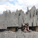
View from the Karang Bolong Rock

The name Karang Bolong means Rock (Karang) with a Hole (Bolong). The Rock was created by frozen lava, formed during the eruption of Mount Karakatau. Karang Bolong beach is located 50 km from Serang town or 140 km from Jakarta, on Karang Bolong Street. This is one of the main tourist attraction in the Anyer area.

The weather was little bit dull at the time this picture was taken,

Hope to catch the clear blue sky next trip.

Copyright: Dominic Julian
Type: Spherical
Resolution: 8000x4000
Taken: 16/10/2015
Caricate: 06/11/2015
Numero di visualizzazioni:

...


Tags: beach; sunset; rock; karang bolong; anyer; banten; indonesia
More About Indonesia


It looks like you’re creating an order.
If you have any questions before you checkout, just let us know at info@360cities.net and we’ll get right back to you.