Toggle navigation
Search
Search
ログイン / 参加
ログイン
New Account / View Pricing
さらなる探求
360° Video Gallery
世界地図
編集者のお勧め
ギガピクセル
360° Stereoscopic Panoramas
Learn
CONTRIBUTE
LICENSE
EARN $ FROM YOUR WORK
FREE RESEARCH
さらなる探求
360° Video Gallery
Gigapixel Gallery
Curated Sets
世界地図
360° Stereoscopic
編集者のおすすめ
More
Learn
CONTRIBUTE
LICENSE
EARN $ FROM YOUR WORK
FREE RESEARCH
参加/ログイン
ログイン
Get a new Contributor Account
Get a new Licensing Customer Account
Newsletter
×
Lightboxes
Copy
Create New Lightbox
This Lightbox is empty
×
Saved!
Search Results for @tags aerial sunset
Keywords
Location
Contributor
Show only licensable content
Show live previews
Search
Keyword Tip: Use quotation marks ("Golden Gate Bridge") to search for an exact phrase.
More tips
.
パノラマ (+10000)
Videos (1365)
Contributors (8)
William L
Old Sherwin Grade Road (aerial)[1]
18800 x 9400
William L
Old Sherwin Grade Road (aerial)[2]
18800 x 9400
William L
Highway 44/Highway 89 intersection (aerial)
18800 x 9400
William L
Highway 19/Oak Bay Road (aerial)
18800 x 9400
William L
Butte Falls-Fish Lake Road (aerial)
18800 x 9400
Vasilis Triantafyllou
Aerial 360 Over Thames River London
16384 x 8192
William L
Lake Tahoe - Meeks Bay (aerial)[2]
18800 x 9400
William L
Medicine Lake Glass Flow (aerial)[1]
18800 x 9400
William L
Medicine Lake Glass Flow (aerial)[2]
18800 x 9400
William L
Bolt Mountain (2241'/683m) summit (aerial)
18800 x 9400
William L
Highway 230 - Rabbit Ears viewpoint (aerial)
18800 x 9400
William L
Randolph E. Collier Rest Area (aerial)
18800 x 9400
William L
Badger Mountain (5019'/1530m) summit (aerial)
18800 x 9400
William L
Likely Mountain (7376'/2248m) summit (aerial)
18800 x 9400
William L
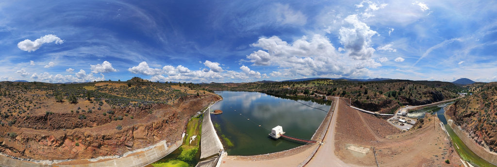
Iron Gate Reservoir Dam (aerial)[1]
18800 x 9400
William L
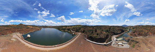
Iron Gate Reservoir Dam (aerial)[2]
18800 x 9400
William L
The Whaleback (8528'/2599m) summit (aerial)
18800 x 9400
William L
Mackenzie River Ferry Crossing (aerial)[1]
18800 x 9400
William L
Dempster Highway - Richardson Mountains (aerial)[1]
18800 x 9400
William L
Ogilvie River/Engineer Creek confluence (aerial)
18800 x 9400
William L
Yukon River - Five Finger Rapids (aerial)
18800 x 9400
William L
NF-41/NF-4150 intersection (aerial)
18800 x 9400
William L
Vedder Road - Joanne Pedersen disappearance (aerial)
18800 x 9400
William L
Inuvik-Tuktoyaktuk Highway - tundra transition (aerial)
18800 x 9400
← Previous
-
1
-
2
-
…
-
98
-
99
-
100
-
101
-
102
-
103
-
104
-
105
-
106
-
…
-
416
-
417
-
Next →
Cookies help us deliver great service to you. By using this site, you agree to the use of cookies.
OK
Leave this Site