Toggle navigation
Search
Search
Вход / Регистрация
Вход
New Account / View Pricing
Исследовать
360° Video Gallery
Карта Мира
Выбор Редактора
Гигапиксельные панорамы
360° Stereoscopic Panoramas
Learn
CONTRIBUTE
LICENSE
EARN $ FROM YOUR WORK
FREE RESEARCH
Исследовать
360° Video Gallery
Gigapixel Gallery
Curated Sets
Карта Мира
360° Stereoscopic
Выбор редактора
More
Learn
CONTRIBUTE
LICENSE
EARN $ FROM YOUR WORK
FREE RESEARCH
Регистрация/Вход
Вход
Get a new Contributor Account
Get a new Licensing Customer Account
Newsletter
×
Lightboxes
Copy
Create New Lightbox
This Lightbox is empty
×
Saved!
Search Results for @tags level
Keywords
Location
Contributor
Show only licensable content
Show live previews
Search
Keyword Tip: Use quotation marks ("Golden Gate Bridge") to search for an exact phrase.
More tips
.
Панорамы (5231)
Videos (25)
Contributors (0)
Sebastian Bauer
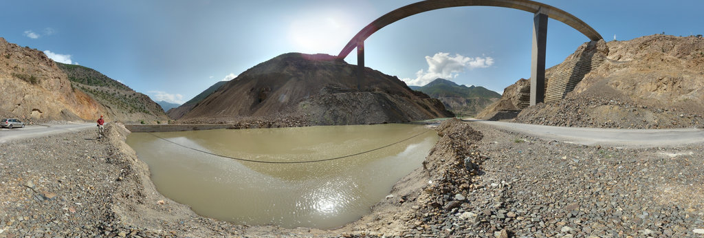
Berta Viaduct and old Berta Bridge on 4 August 2012 with Deriner Lake Water Level at 285.10 masl and Photographer
18812 x 9406
Sebastian Bauer
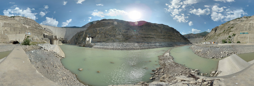
Deriner Dam upstream right Bank View on 2 June 2012 and Deriner Lake Water Level at 240.94 masl with Photographer
18748 x 9374
Sebastian Bauer
Çoruh and Berta Rivers Confluence with Berta Bridge on 2 February 2012 with Deriner Lake Water Level at 205.48 masl
18732 x 9366
Sebastian Bauer
Deriner Reservoir seen from Exploratory Tunnel T2 on 22 September 2012 with Lake Water Level at 304.70 masl and Photographer
18740 x 9370
Sebastian Bauer
Berta Viaduct and old Bridge during Impounding on 4 August 2012 with Lake Water Level at 285.10 masl and Photographer
18816 x 9408
Sebastian Bauer
Old Arch Bridge on 21 August 2012 barely visible in the morning with Deriner Lake Water Level at 295.29 masl
18824 x 9412
Sebastian Bauer
Center of Old Arch Bridge in the morning of 19 August 2012 with Water Level at masl 294.32 and Photographer
18896 x 9448
[email protected]
Tenby Aerial 360
15500 x 7750
[email protected]
Cardiff International Sports Village Aerial Panorama
14336 x 7168
Sebastian Bauer
Zeytinlik Arc Bridge gone under as seen on 22 September 2012 with a Water Surface Level at 304.70 masl with Photographer
18760 x 9380
Sebastian Bauer
Deriner Reservoir seen on 22 September 2012 from near Exploratory Tunnel T3 with Reservoir Water Level at 304.70 masl with Photographer
18760 x 9380
Sebastian Bauer
Deriner Lake on 18 September 2012 seen from Access Tunnel to Road Tunnel with Water Level at 303.69 masl with Photographer
18748 x 9374
Sebastian Bauer
Zeytinlik Arch Bridge on 11 March 2012 with Deriner Lake Water Level at 235.23 masl and Flock of Goats and Sheep
18780 x 9390
Sebastian Bauer
Zeytinlik Arch Bridge on 5 March 2012 during impounding of Deriner Lake with a Lake Water Level Elevation at 230.14 masl
18796 x 9398
Sebastian Bauer
Deriner Dam left Bank downstream View with empty Çoruh River on 11 June 2012 and Reservoir Water Level at 249.49 masl
18800 x 9400
Sebastian Bauer
Deriner Dam left Bank downstream View on 11 June 2012 with empty Çoruh River and Lake Water Level at 249.49 masl
18748 x 9374
Sebastian Bauer
Berta Viaduct View onto future Deriner Lake during Impounding on 4 August 2012 with Water Level at 285.10 masl and Photographer
18716 x 9358
Sebastian Bauer
Deriner Dam seen from between Exploratory Tunnels T1 and T2 on 24 September 2012 with Lake Water Level at 305.26 masl
18768 x 9384
Sebastian Bauer
Center of Old Arch Bridge early evening on 18 August 2012 with Deriner Lake Water level at 293.84 masl with Photographer
18952 x 9476
Алексей Меринов
by the mountain (altitude 289 meters above sea level), overgrown with autumn deciduous forest not far from the village of Shabanovskoe
20418 x 10209
Sebastian Bauer
Çoruh River left Bank with Tunnel Adit seen from the River on 15 July 2012 with Deriner Lake Level at 270.06 masl
18828 x 9414
Sebastian Bauer
Çoruh River left Bank View underneath Tunnel Adit seen on 15 July 2012 from the River with Water Level at 270.06 masl
18844 x 9422
Sebastian Bauer
Deriner Dam View from left Bank highest Point on 25 September 2012 with Deriner Lake Water Level at 305.53 masl with Photographer
18728 x 9364
Sebastian Bauer
Deriner Dam downstream right Bank View on 13 June 2012 Panorama with Orifice Spillways closed and upstream Lake Level at 254.63 masl
18760 x 9380
← Previous
-
1
-
2
-
…
-
26
-
27
-
28
-
29
-
30
-
31
-
32
-
33
-
34
-
…
-
195
-
196
-
Next →
Cookies help us deliver great service to you. By using this site, you agree to the use of cookies.
OK
Leave this Site