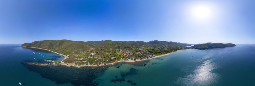
Seen from the Sky

Collection of my most beautiful aerial shots

The Kyzylkup Tract is one of the most spectacular geological attractions in the Mangystau region of western Kazakhstan. This area is world-famous, nicknamed "Tiramisu Mountains" due to its distinctive striated hills, reminiscent of the layers of t...
Bozzhira Canyon is a spectacular geological depression located on the Ustyurt Plateau, in the remote Mangystau region of Kazakhstan. This surreal, Martian-like landscape, characterized by towering white chalk cliffs and limestone spires, is the bo...
Sor Tuzbair is a spectacular salt marsh located in the semi-arid Mangystau region of southwestern Kazakhstan. Often compared to the famous Salar de Uyuni in Bolivia, this immense salt flat stretches across the foothills of the Ustyurt Plateau, off...
Bozzhira Canyon is a spectacular geological depression located on the Ustyurt Plateau, in the remote Mangystau region of Kazakhstan. This surreal, Martian-like landscape, characterized by towering white chalk cliffs and limestone spires, is the bo...
The Airakty Valley of Castles, located in Kazakhstan's remote Mangystau region, is a stunning landscape of isolated limestone mountains carved by wind and rain into formations resembling ancient, fortified fortresses. The name was poetically coine...
Ilulissat Icefjord is a fjord in western Greenland. Located 250 km north of the Arctic Circle, the Ilulissat Icefjord runs west 40 km (25 mi) from the Greenland ice sheet to Disko Bay just south of the town of Ilulissat. Ilulissat Icefjord was dec...
Cetina (pronounced [tsětina]) is a river in southern Croatia. It has a length of 101 km (63 mi) and its basin covers an area of 1,463 km2 (565 sq mi). From its source, Cetina descends from an elevation of 385 metres (1,263 ft) above sea level to t...
Lake Vico (Italian: Lago di Vico) is a caldera lake in the northern Lazio region, central Italy. It is one of the highest major Italian lakes, with an altitude of 510 m. Administratively, it is part of the municipalities of Caprarola and Ronciglio...
Syvota (Greek: Σύβοτα, pronounced [ˈsivota], before 1940: Μούρτος Mourtos[2] pronounced [ˈmurtos]) is a village and a former municipality in Thesprotia, Epirus, Greece. Since the 2011 local government reform it is part of the municipality Igoumeni...
The Latemar is a mountain in the Dolomites on the border between South Tyrol and Trentino, Italy. It is a popular hiking destination. It is best known for its view from the Karersee lake. original size 18000x9000www.abagontheroad.com
Ilulissat Icefjord is a fjord in western Greenland. Located 250 km north of the Arctic Circle, the Ilulissat Icefjord runs west 40 km (25 mi) from the Greenland ice sheet to Disko Bay just south of the town of Ilulissat. Ilulissat Icefjord was dec...
Kangaamiut is located on an island off the coast of Davis Strait between mouths of two long fjords. To the south is the long and twisted Kangerlussuatsiaq Fjord and to the north is the Kangaamiut Kangerluarsuat Fjord. The mouth of the long Kangerl...
Ilulissat Icefjord is a fjord in western Greenland. Located 250 km north of the Arctic Circle, the Ilulissat Icefjord runs west 40 km (25 mi) from the Greenland ice sheet to Disko Bay just south of the town of Ilulissat. Ilulissat Icefjord was dec...