Open Map
Close Map
N
Projektioner och Nav lägen
  • Normal View
  • Fisheye View
  • Architectural View
  • Stereographic View
  • Little Planet View
  • Panini View
Click and Drag / QTVR mode
Dela detta panorama
För icke-kommersiellt bruk
Detta panorama kan bäddas in på en icke-kommersiell webbplats utan kostnad. Läs mera
Vill du gå med på Terms & Conditions?
För kommersiellt bruk, kontakta oss
Bädda in detta panorama
BreddHöjd
För icke-kommersiellt bruk
För kommersiellt bruk, kontakta oss
LICENSIERA MODAL

0 Likes

Horseshoe Bend on Owens Gorge
California
Here the Owens River flows from Crowley Reservoir through Owens Valley and down to Bishop. Much of the water now has been diverted to Los Angeles by way of a 200 plus mile aqueduct. 
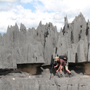
The river cuts through the Volcanic Tablelands, a vast volcanic landscape that was formed over 700,000 years ago by volcanic ash and material from the Long Valley caldera northwest of here to create the Owens River Gorge.
Copyright: Allan Der
Typ: Spherical
Upplösning: 6846x3423
Taken: 03/07/2010
Uppladdad: 27/11/2013
Visningar:

...


Tags: aqueduct; bend; bishoptuff; ca; california; climbing; desert; eastern sierra; horseshoe; inyo county; ladwp; mono county; owens river; river; vocanic tableland; volcanic; water
Mer om California


It looks like you’re creating an order.
If you have any questions before you checkout, just let us know at info@360cities.net and we’ll get right back to you.